Thursday, June 17, 2021

COMMON POCHARD BIRD IN NIT AGARTALA, TRIPURA


Common pochard bird is generally known as 'Diving Duck' mostly found in Northern Europe region. The scientific name of the bird is driven from 'aithuia' an unidentified seabird mentioned by author like Hesychius, Aristotle, and Latin Ferina 'Wild game' from ferus 'wild'. 


Common pochard bird are taking snapping in the lake. Some birds are still awakening, it may be some kind of duty for alerting mode for other companions. These birds are so clever, because if anybody tried to come closer than they quickly fly in the sky.


Huge number of the bird has been occupied the surface of the lake water. it may be birds are tired after many thousands journey from northern European region such as Siberia, Norway or Sweden. 


Some Diving duck are taking snapping in the marginal portion of the lake. Some birds are looking for the food resources. Near the lake margin where land mass meets soil are wetted so birds can easily search their food resource from that muddy soil. 


Diving ducks are always flies into making a group. a leader bird will be always in the front, and other will follow him by flying arc shape. This arc shape flight is very helpful during long distance flying. In a recent study scientist found that birds can save 20% their body energy by doing this shape.

Common pochard have very beautiful look, 
The adult male has a long dark bill with a grey band, a red head and neck, a black breast, red eyes and a grey back. The adult female has a brown head and body and a narrower grey bill-band. The triangular head shape is distinctive. Pochards are superficially similar to the closely related North American redhead and canvasback.
These are gregarious birds, forming large flocks in winter, often mixed with other diving ducks such as the tufted duck, with which they are known to hybridise. These birds are habituate to fly into a group. In this photo we can see that Common pochard are flying into making group and acting almost altogether. There they are able to maintain discipline among their community. Most probably this acting are adopted by their new born baby too by following. 


Huge number of the birds are taking shelters in beside land mass portion of the lake. Most probably, they are searching for food resources. This lake has enough food resources to sustain Common pochard for few months, after passing winter they will fly for their native places for breeding. 

Females give hoarse growls. Males have whistles cut off by a final nasal note aaoo-oo-haa. They making pair when they are need. Generally they came here for passing winters, because during winter in Siberian or northern European region winter are so extreme cold (almost every land or sea mass covered by ice sheet). 


These are gregarious birds, forming large flocks in winter, often mixed with other diving ducks such as the tufted duck, with which they are known to hybridise.[citation needed]

These birds feed mainly by diving or dabbling. They eat aquatic plants with some molluscs, aquatic insects and small fish. They often feed at night, and will up-end for food as well as the more characteristic diving. According to the article 'Patterns in the diving behaviour of the pochard, Aythya ferina: a test of an optimality model' Pochard's have a behavioral preference when it comes to their feeding patterns. This behavioral preference is that Pochards prefer shallower water in comparison to deeper water even though the food concentration in deeper water may be higher.

DISTRIBUTION AND HABITAT


Their breeding habitat consists of marshes and lakes with a metre or more water depth. Pochards breed in much of temperate and northern Europe and across the Palearctic. They are migratory, and spend winter in the south and west of Europe.

In the British Isles, birds breed in eastern England and lowland Scotland, in small numbers in Northern Ireland with numbers increasing gradually, and sporadically in the Republic of Ireland, where it may also be increasing. While uncommon, individuals are also occasionally seen in the south of England, and small populations are sometimes observed on the River Thames. Large numbers stay overwinter in Great Britain, after the birds retreat from Russia and Scandinavia.


COMMON POCHARD BIRDS IN THE LAKE OF NIT AGARTALA CAMPUS


They comes to Indian Sub-continent from Northern European countries by flying more than thousands km. Almost every year these area's marshy land and lakes are full of these kind of Siberian birds. They comes here for protecting themselves from hard climate of Siberian region. They feel warmer in compare than Siberian region even here we feel very cold in winter.

We found these Common Pochard bird in NIT Campus of Agartala during winter (December) of 2019. We saw there were full occupied the lake by these birds. For breeding they again goes to their native place in the different parts of the Northern European countries by flying again more than many thousands km flight. 


Published also on YouTube's 'The Geographia' Channel.

For subscribe click on ... https://www.youtube.com/channel/UCY2p

Thanks for here being with us.

#CommonPochardBird #DivingDuck #DivingDuckInIndia

All copywrite belongs to @THE GEOGRAPHIA, 2021

If you have any kind of questions please don't hesitate to contact to ....

Dr. Rajesh Kumar Mahato,
mahtolu@gmail.com   
or WhatsApp on +91-9749620779
Assistant Teacher (PGT) in Geography, 


We are connected with FACEBOOK, INSTAGRAM, TWEETER etc..

You are reading this content on Blog: https://thegeographia.blogspot.com/


Monday, June 14, 2021

LGBT RALLY, MILAN, ITALY (EUROPE)


LGBT RALLY IN MILAN, ITLAY (EUROPE)


LGBT rally in Milan, Italy is a type of parade and festival held at the every June each year in Milan City of Italy by Lesbian, Gay, Bisexual and Transgender. 

It is a unique type of Parade occurred once in a year in Europe by these community to show unity among Humanity. Since 2013 this rally have been organized as 'Milano Pride'. 


Milano Parede (LGBT Rally in Milan, Italy)


Fortunately in June month of 2019 I became witness to see this beautiful parade in which this parade have been celebrated by not only by LGBT, its common people too who have been participated to support this movement. 

An unique seven color flag is symbolic for LGBT community. This is very unique culture and anthropological changing signals among modern societies which needs to understand by research. 

                                
                        Some Slogans pamphlets written in the support of LGBT community


International Flag for LGBT community

This event (LGBT Rally) is an unique example in the world and also a great concern for the Gender studies in Population Geography. 

Italy is an technological advanced country and included into developed nations. Society is also on the advanced level therefore, this is great concern for Social scientist that if a society become on advanced level then is there changes to repeat this kind of event or community development in the upcoming developing countries too. It may be develop. 


Decorated Vehicles 


People are Dancing and sharing love


Full Awareness Program


Volunteers are taking care for the success of the Rally


LGBT Community and their supporters


Milano Railway station Street are full of Rally people


Pamphlets in the support of LGBT community


More Supporters


This rally is an example for other people living in the various parts of the world. Recently Indian Supreme Court have been given decision in the favour of LGBT community. 

See more information on: https://en.wikipedia.org/wiki/LGBT_rights_in_India


It will be very interesting to grasp that what is the future of our human civilization, what will be happen after 100 or 1000 years after. Is this LGBT community will be more, is there will a different society what today we look as.  this is a new dimension of thinking and new research study calling for social scientist under the theme of Gender Studies. Please don't hesitate to share your thoughts on LGBT ; What you are thinking?


For video streaming you can streaming on ...


All copywrite belongs to @THE GEOGRAPHIA, 2021

If you have any kind of questions please don't hesitate to contact to ....


Dr. Rajesh Kumar Mahato,
mahtolu@gmail.com   
or make a WhatsApp on +91-9749620779
Assistant Teacher (PGT) in Geography, 
N. D. Rashtriya Vidyalaya (H.S.), Sitarampur, 
Paschim Burdwan, West Bengal, INDIA


Click for Subscribe the Channel https://www.youtube.com/channel/UCY2p...

We are connected with FACEBOOK, INSTAGRAM, TWEETER etc..

Blog: https://thegeographia.blogspot.com/

#LGBTRalley #MilanoPride #LGBTRalleyInMilano #PridoWeek


Sunday, June 13, 2021

GLACIAL LAKE OUTBURST FLOOD (GLOF)


A glacial lake outburst flood (GLOF) is a type of outburst flood that occurs when the dam containing a glacial lake fails. An event similar to a GLOF, where a body of water contained by a glacier melts or overflows the glacier, is called a jökulhlaup. The dam can consist of glacier ice or a terminal moraine. Failure can happen due to erosion, a buildup of water pressure, an avalanche of rock or heavy snow, an earthquake or cryoseism, volcanic eruptions under the ice, or massive displacement of water in a glacial lake when a large portion of an adjacent glacier collapses into it.

Natural occurrence of GLOF environemnt

Glacial lakes are common in the high elevation of glacierised basin. They are formed when glacial ice or moraines or natural depressions impound water. There are varieties of such lakes, ranging from melt water ponds on the surface of glacier to large lakes in side valleys dammed by a glacier in the main valley.

Location of major GLOF sites in Himalayan range 

Elevation is the major factor behind creation of these type of lakes. Averagely in Himalayan point of view most of glacier lakes are found above than 4,000 to 6,000 meters. Valley or mountain glaciers are main source of feeding points for making glacier lakes. More than 6,000 meter elevation there are location of permanent glaciers there, it is not possible to make any glacier lake. Glacier lake are found and create lower than snow line that is almost 6,000 meters in the whole Himalayan mountain system ranging from east to west. After 4,000-5,000 meters High Himalaya’s ‘U’ shaped valley is starting to convert into ‘V’ shaped valley where very narrow type of landscape creates; glacier lake’s small neck size outlet drainage system start to move in the downward direction. During extreme winter these glacier lake gets totally freeze down therefore the size (horizontal and vertical both) begins to increase. In the month of February to March glacier lake start to develop cracks in the lake’s top or outside ice sheet, due to continuous increase in atmospheric temperature, glacier lake start to receive more water mass from melting ice water from upside. Therefore, glacier lake lost their capability to manage water mass and suddenly thin neck (downward margin of the lake) of the lake start to outburst and huge amount of water mass mixing with snow and rock boulders begins to roll down in the valley, which is very dangerous for the dwellers (villagers) and wild species, natural vegetation situated beside the river. This is very common natural phenomena in the entire Himalayan system on the same height. Where density of population is high damage will be high and in the scanty population region it will effect less. Here is some major GLOF occurred in the whole Himalayan system.

India: In 1929, a GLOF from the Chong Khumdan Glacier in the Karakoram caused flooding on the Indus River 1,200 km downstream (a maximum flood rise of 8.1 m at Attock).

On 7 February 2021, part of Nandadevi Glacier broke away, triggering a GLOF sweeping away a power plant. More than 150 people were feared dead.

Bhutan: GLOFs occur with regularity in the valleys and low lying river plains of Bhutan. In the recent past, flash floods have occurred in the Thimphu, Paro and Punankha-Wangdue valleys. Of the 2674 glacial lakes in Bhutan, 24 have been identified by a recent study as candidates for GLOFs in the near future. In October 1994, a GLOF 90 kilometres (56 mi) upstream from Punakha Dzong caused massive flooding on the Pho Chhu River, damaging the dzong and causing casualties.

In 2001, scientists identified Lake Thorthormi as one that threatened imminent and catastrophic collapse. The situation was eventually relieved by carving a water channel from the lip of the lake to relieve water pressure.

Nepal: Even though GLOF events have been occurring in Nepal for many decades, the Dig Cho glacial lake outburst, which took place in 1985, has triggered detailed study of this phenomenon. In 1996, the Water and Energy Commission Secretariat (WECS) of Nepal reported that five lakes were potentially dangerous, namely, Dig Tsho, Imja, Lower Barun, Tsho Rolpa, and Thulagi, all lying above 4,100 m. A recent study done by ICIMOD and UNEP (UNEP, 2001) reported 20 potentially dangerous lakes in Nepal. In ten of them GLOF events have occurred in the past few years and some have been regenerating after the event. Additional dangerous glacial lakes may exist in parts of Tibet that are drained by streams crossing into Nepal, raising the possibility of outburst incidents in Tibet causing downstream damage in Nepal. The Gandaki River basin is reported to contain 1025 glaciers and 338 lakes.

Thulagi glacier The Thulagi glacier, which is located in the Upper Marsyangdi River basin, is one out of the two moraine-dammed lakes (supra-glacial lakes), identified as a potentially dangerous lake. The KfW, Frankfurt, the BGR (Federal Institute for Geosciences and Natural Resources, Germany), in cooperation with the Department of Hydrology and Meteorology in Kathmandu, have carried out studies on the Thulagi Glacier and have concluded that even assuming the worst case, a disastrous outburst of the lake can be excluded in the near future.

Tibet: Longbasaba and Pida lakes are two moraine-dammed lakes at an altitude of about 5700 m in the Eastern Himalayas. Due to the rise of temperature, the areas of the Longbasaba and Kaer glaciers decreased by 8.7% and 16.6% from 1978 to 2005. Water from glaciers directly flowed into Longbasaba and Pida lakes, and the area of the two lakes increased by 140% and 194%. According to the report of the Hydrological Department of Tibet in 2006, if a GLOF had occurred at the two lakes, 23 towns and villages, where more than 12,500 people live, would have been endangered.

In Tibet, one of the major barley producing areas of the Tibetan Plateau was destroyed by GLOFs in August 2000. More than 10,000 homes, 98 bridges and dykes were destroyed and its estimated cost was about $75 million. The farming communities faced food shortages that year by losing their grain and livestock.

A major GLOF was reported in 1978 in the valley of the Shaksgam River in the Karakoram, a part of historic Kashmir, ceded by Pakistan to China.


Recent GLOF occurrence of Nandadevi Glacier: 

On 7 February 2021, part of Nandadevi Glacier broke away, triggering a GLOF sweeping away a power plant. The Nanda Devi glacier forms part of the second-highest mountain in India - the Nanda Devi Mountain. While it the second-highest after Kangchenjunga, it is the highest mountain located entirely within the country as Kangchenjunga lies on the border of India and Nepal. 

Glacier lake formation due to melting of glaciers in the upper catchment regions


Natural Glaciers developed over the frozen lake


After the flash flood event situation of the river valley (blowing of icesheets with flash flood)


On the northern side of the Nanda Devi lies the Uttari Nanda Devi Glacier which flows into the 'Uttari Rishi Glacier'. To the southwest lies the Dakkhini Nanda Devi Glacier which flows into the Dakkhini Rishi Glacier. All of these glaciers drain west into the Rishiganga. 

Flash flood also affected the downstream hydro project of National Thermal Power Corporation Limited at Tapovan on the river Dhauliganga, which is a tributary of the river Alaknanda. More than 150 labourers working in the power project are missing. Environment experts have called for a review of power projects in the ecologically sensitive mountains.

There is no danger of downstream flooding and the rise in water level has been contained, as per the information given by the Central Water Commission,” says the government. “There is also no threat to the neighboring villages. At the same time, the concerned agencies of the Centre and the State were asked to keep a strict vigil on the situation.

GLOF in the Chamoli valley, Uttarakhand 


Destroyed dam near Chamoli in Uttarakhand after GLOF event


GLOF of Chamoli in print media


This kind of GLOF occurrence need to continuous monitor by scientist community. There are number of site which could be convert into GLOF disaster in many places where potential glacier lake develops particularly during end of the winter. 


REFERENCES:

1.     Hewitt, K. (1982) Natural dams and outburst floods of the Karakoram Himalaya Archived 21 July 2011 at the Wayback Machine.

2.     150 NTPC workers missing after glacier triggers flood in Uttarakhand". mint. 7 February 2021. Retrieved 7 February 2021.

3.     Chhopel, Karma (15 March 2006). "Flash Floods and Debris Flows due to Glacial Lake Outburst Floods" (ppt). Proceedings of the International Workshop on Flash Flood Forecasting coordinated by the U.S. National Oceanic and Atmospheric Administration's National Weather Service and the World Meteorological Organization, San José, Costa Rica, March 2006. Conference web site (NOAA), Abstract (pdf). Thimphu, Bhutan: Hydro-Met Services Division, Dept. of Energy, Ministry of Trade and Industry.

4.     Wangda, Dorji (9 September 2006). "GIS Tools Demonstration: Bhutan Glacial Hazards" (PDF). Proceedings of the LEG Regional Workshop on NAPA coordinated by UNITAR, Thimphu, Bhutan, September 2006. Conference web site (UNITAR). Dept, of Geology and Mines, Govt. of Bhutan. Archived from the original (PDF) on 24 August 2006.

5.     Leslie, Jaques (17 June 2013). "A Torrent of Consequences"(article). World Policy Journal, New York, Summer 2013. New York City: World Policy Institute.

6.     BGR/NLfB/GGA: Gletschersee Thulagi Archived 18 July 2011 at the Wayback Machine.

7.     Xin, Wang; Shiyin, Liu; Wanqin, Guo; Junli, Xu (2008). "Assessment and Simulation of Glacier Lake Outburst Floods for Longbasaba and Pida Lakes, China". Mountain Research and Development. 28 (3/4): 310–317. doi:10.1659/mrd.0894.

8.     WWF Nepal Program. "An Overview of Glaciers, Glacier Retreat, and Subsequent Impacts in Nepal, India and China". 14 March. 2005

ICIMOD, Kathmandu, NEPAL (for the animated video) - https://www.youtube.com/watch?v=awLGxl5JmjY


THANK YOU SO MUCH for being here...


Monday, February 22, 2021

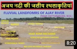
अजय नदी की जलीय स्थलाकृतियां


अजय नदी की उत्पति ३०० मीटर की उचाई से देवघर के दछिण, झारखण्ड से हुआ है। पश्चिम बंगाल में यह नदी चित्तरंजन के सिमजूरी गांव के नजदीक आती है। अजय नदी की कुल लम्बाई लगभग २८८ किलोमीटर है। यह नदी कटवा के नजदीक स्थित भगीरथी नदी से मिल जाती है। इसकी कुल अपवाह प्रणाली क्षेत्रफल ६००० वर्ग किलोमीटर है ।


जलीय स्थलाकृतियां: बहता हुआ जल द्वारा निर्मित स्थलाकृतियो को जलीय स्थलाकृति कहा जाता है जिनमे जलगर्तिकाये, जलछीप्रिकाये, बालूका स्तर, रिपल्स, तटकटाव, नालिकाये, जलप्रपात एवं अनेको शुक्ष्म जलीय स्थलाकृतियों का निर्माण होता है ।

जलगर्तिकाये: जल गर्तिकाये नदी के किनारों अथवा नितलीय सतह पर एक परिपत्र या बेलनाकार छेद है जो पानी और घर्षण के बल द्वारा उत्पादित है। इसके निर्माण में चट्टानी संधियों एवं जल गतिक्रिया की भूमिका महत्वपूर्ण होती है। चूकि अजय नदी में ग्रेनाइट जैसे चट्टानों की अधिकता है जिसके कारण यहाँ जल गर्तिकाओ की भरमार है। जैसा की हम देख रहे है कि इस जलगर्तिका में बेसाल्ट चट्टान की संधियों के सहारे जल गर्तिकाओ का निर्माण किया है एवं बहुत सारे चट्टानों में यह बनने की प्रारंभिक अवस्था में है। इन जल गर्तिकाओ में चट्टानी टुकड़े फसे हुए होते है जो दरअसल में जल गर्तिकाओ की गहराई को बढ़ाने में मदद करती है।

अजय नदी में स्थित जल गर्तिकाये

जलछीप्रिकाये: जल प्रवाह की सतह से ऊपर उजागर हुए कुछ चट्टानों के साथ नदी में पाए जाते हैं। इसमें चट्टानों के ऊपर और चारों ओर पानी बहता है, हवा के बुलबुले इसके साथ मिश्रित हो जाते हैं और सतह के कुछ हिस्से को एक सफेद रंग प्राप्त होता है, जिसे "व्हाईटवेटर" कहा जाता है। जलछीप्रिका के नीचे बिस्तर सामग्री अत्यधिक प्रतिरोधी होती है ठोस चट्टानों में बहने वाली बहुत छोटी धाराओं में उनकी लंबाई बहुत अधिक होती है जलछीप्रिकाये जल के वायु प्रवाह के कारण बेहतर पानी की गुणवत्ता वाली होती हैं।

अजय नदी में स्थित जलछीप्रिकाये


We are active on - Facebook : https://www.facebook.com/ YouTube: https : https://www.youtube.com/channel/UCY2pFE8rjZX9NUSsaNXgK6Q?sub_confirmation=1 Email id : mahtolu@gmail.com Google plus : https://plus.google.com/ ResearchGate : https://www.researchgate.net/home?ref=home Blog : https://thegeographia.blogspot.com/


RIVER SYSTEM AND LANDFORMS UNDERSTANDING TROUGH THE MODEL


In this article we will understand River System and associated landforms. Three types of landforms are associated with a river system i.e., Glacial landforms, Fluvial landforms and Coastal landforms. We tried to elaborate all kind of landforms which forms through Glacier, River water and Coastal water in very short.


Before looking at specific river landforms it is important to look at how the river channel itself changes downstream. We have already looked at how the river channel in the upper course is shallow and narrow with large bedload that disrupts the efficiency of flow. The bedload is derived mainly from mass movements from the valley sides and eroded rock from the bed and banks of the channel. The valley profile is really just an extension of the channel itself; it follows a symetrical v-shaped form. This narrow valley and river channel is caused by vertical erosion as a result of the high potential energy of the river. As the river stretches downstream both its velocity and discharge increase. Its velocity increases due to more efficient flow and reduced channel roughness. The discharge increases because the catchment area of the drainage basin has increased along with the number of tributaries feeding water into the river. As a result of this increased discharge the river, in its attempt to balance its energy erodes laterally, widening as well as deepening the river channel. At times, the river will exceed the banks and flood across the flatter section of the valley, initially in a youthful phase a floodplain may be eroded out of the valley. Over time a flat extended floodplain devlops either on both sides of the river or dominant on one side.  Again in an effort to balance its energy and discharge the river will meander, creating asymetrical river channels; characterised by steep river cliffs on the outside bend of the meander and gentle slip-off slopes on the inside bend of the meander. Unregulated floodplains support permanent and semi-permanent wetlands. Further downstream the floodplain grows in size on both sides of the river as the river channel grows in width and depth. The channel shape becomes once again more symetrical as the channel widens. The meander length and meander belt both increase in size and the erosion of the outside bend slows down.


All copywrite belongs to @THE GEOGRAPHIA, 2021

If you have any kind of questions please don't hesitate to contact to ....
Dr. Rajesh Kumar Mahato,
mahtolu@gmail.com   

Assistant Teacher (PGT) in Geography, 
N. D. Rashtriya Vidyalaya (H.S.), Sitarampur, 
Paschim Burdwan, West Bengal, INDIA

Expertize in FLUVIAL GEOMORPHOLOGY, CLIMATE CHANGE & GIS

Click for Subscribe the Channel https://www.youtube.com/channel/UCY2p...​

We are connected with FACEBOOK, INSTAGRAM, TWEETER etc..


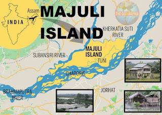
MAJULI ISLAND - WORD'S BIGGEST RIVER MADE ISLAND IN BRAHMPUTRA

Majuli Island - Mājuli or Majoli is a river island in the Brahmaputra River, Assam and in 2016 it became the first island to be made a dist...